 Enchanted Rock State Natural Area consists of 1643.5 acres
on Big Sandy Creek, north of Fredericksburg, on the border between Gillespie and Llano
Counties. It was acquired by warranty deed in 1978 by the Nature Conservancy of Texas,
Inc., from the Moss family. The state acquired it in 1984, added facilities, and reopened
the park in March 1984, but humans have visited here for over 11,000 years. Enchanted Rock
was designated a National Natural Landmark in 1970 and was placed on the National Register
of Historic Places in 1984. The Rock is a huge, pink granite exfoliation dome, that rises
425 feet above ground, 1825 feet above sea level, and covers 640 acres. It is one of the
largest batholiths (underground rock formation uncovered by erosion) in the United States.
. Enchanted Rock State Natural Area consists of 1643.5 acres
on Big Sandy Creek, north of Fredericksburg, on the border between Gillespie and Llano
Counties. It was acquired by warranty deed in 1978 by the Nature Conservancy of Texas,
Inc., from the Moss family. The state acquired it in 1984, added facilities, and reopened
the park in March 1984, but humans have visited here for over 11,000 years. Enchanted Rock
was designated a National Natural Landmark in 1970 and was placed on the National Register
of Historic Places in 1984. The Rock is a huge, pink granite exfoliation dome, that rises
425 feet above ground, 1825 feet above sea level, and covers 640 acres. It is one of the
largest batholiths (underground rock formation uncovered by erosion) in the United States.
.
History: Tonkawa Indians
believed ghost fires flickered at the top, and they heard weird creaking and groaning,
which geologists now say resulted from the rock's heating by day and contracting in the
cool night. A conquistador captured by the Tonkawa described how he escaped by losing
himself in the rock area, giving rise to an Indian legend of a "pale man swallowed by
a rock and reborn as one of their own." The Indians believed he wove enchantments on
the area, but he explained that the rock wove the spells. "When I was swallowed by
the rock, I joined the many spirits who enchant this place." The first
well-documented explorations of this area did not begin until 1723 when the Spanish
intensified their efforts to colonize Texas. During the mid-1700s, the Spaniards made
several trips to the north and northwest of San Antonio, establishing a mission and
presidio on the San Saba River and carrying out limited mining on Honey Creek near the
Llano River.
Activities:
Visitors can enjoy primitive backpacking, camping, hiking, technical and rock
climbing, picnicking, geological study, bird watching, and star gazing (minimal light
pollution). Remember, at Enchanted Rock State Natural Area, do not disturb plant or animal
life, geological features, or Indian or historical artifacts. These park resources are
protected by law! Bring your own firewood. Rock climbers must check in at headquarters;
route maps and climbing rules available.
Directions: The park is 18
miles north of Fredericksburg on Ranch Road 965, or from Llano, take State Highway 16 for
14 miles south and then go west on Ranch Road 965.
Camping fees vary;
entrance fee. For reservations, call 512/389-8900. Current conditions including fire bans
and water levels can vary from day to day. For more details, call the park or Park
Information at 1-800-792-1112.
NOTE: The park reaches capacity
(in terms of parking) and frequently closes on weekends (sometimes as early as 11 a.m.)
Reopening usually occurs at 5 p.m. Call ahead or have alternate plans if you arrive at the
park and find it closed. More
information
Link
to Enchanted Rock climbing map In PDF format
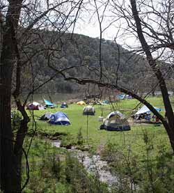
Facilities: Facilities include restrooms with showers;
walk-in water sites (25 to 100 yards) with tent pads, picnic tables, fire rings, and water
and restrooms with showers nearby; hike-in primitive sites, located in three unique areas
with composting toilets (backpack camping in designated areas only); picnic sites for
day-use with tables and grills; a group picnic area with a pavilion and restrooms; a
4-mile trail for backpacking/day hiking that winds around the granite formations; a short,
steep trail leading up to the top of Enchanted Rock (foot traffic only); an interpretive
center; and a Texas State Park Store.No facilities are available for vehicular camping of
any type.
Link to park fee and gate information.
Link
to a map of the Walk-in Tent Area In PDF format
Link to the park facility and trail map In PDF format
Flora/Fauna:The four major
plant communities of Enchanted Rock are open oak woodland, mesquite grassland, floodplain,
and granite rock community. Live oak, post oak, and blackjack oak dominate the oak
woodland, with black hickory in moister areas. Common shrubs are Texas persimmon, agarita,
white brush, and prickly pear. Bluestem, three-awn, and grama grass often are found in the
shade of the oaks, while American tripogon is more common on gravely slopes which are
seasonally wet. The mesquite grassland, once an area of bluestem, is now covered with
three-awn, grama, Texas wintergrass, panicum, and sand bur, along with invading mesquite.
Elm, pecan, hackberry, black hickory, soapberry, and oak characterize the floodplains.
Common shrubs are white buckeye, agarita, Texas persimmon, Roosevelt weed, and buttonbush.
Grasses and sedges, as well as annual and perennial herbs, form the ground cover. Some of
these are water bentgrass, late eupatorium, Indiangrass, bushybeard bluestem, frost weed,
and switchgrass. In the spring bluebonnets, Indian paintbrush, yellow coreopsis,
bladderpod, and basin bellflower bloom.
Elevation: 1825. Weather:
January average minimum 36; July average maximum 95; average annual rainfall 28.7. Open:
Open 7 days a week year-round, except for Public Hunts (call for dates). Busy Season:
Year-round, especially during spring, fall, and winter.
Area
Attractions: Other nearby state parks in this scenic area include Pedernales Falls, Blanco,
Guadalupe River, Kerrville-Schreiner, Inks Lake,
and Longhorn Cavern State Parks; Lyndon
B. Johnson State Historic Site, with the Sauer-Beckmann living history farmstead, and
the adjacent LBJ National Park; the Johnson Birthplace; and the family cemetery, where the
former President is buried; and the Admiral Nimitz
Museum in Fredericksburg. You may want to refer to nearby parks. |


